Lakes News:

    Police continue hunt for killer in Paeroa homicide


    Nearly 10 months on from the discovery of the body of a businessman outside his Paeroa business, Waikato

    Police are continuing their homicide investigation.
    Detective Sergeant Dean Anderson of the Matamata Piako CIB said Jordan Voudouris,  was murdered at the rear of his Pizza store on the 18th of June 2012.
    "In what can be best described as a senseless killing, Mr Voudouris was shot dead resulting in the loss of a well liked local Paeroa businessman and father.
    "The enquiry team is continuing to work through a large amount of information provided to us since his death but we would still like to hear from anyone who may have any information that may assist the enquiry."
    Mr Anderson said Police are committed to finding the killer, or killers, and bringing closure for Mr Voudouris' family and the Paeroa community.
    "We still have a reward in place for any material, information or evidence, which leads to the identity and conviction of any person or persons responsible for his murder.
    "If you have information you can contact the investigation team in confidence via Paeroa Police on 07 862 8744."
    Alternatively, information can be left with Crimestoppers on 0800 555111.

    Music legends set to rock Coromandel this Easte

    Dave Dobbyn. Photo: Supplied. 

    An outstanding line-up of New Zealand’s top musical talent is expected to draw a huge crowd to Whitianga this Easter - with early bird tickets to Shades of Summer 2013 having already sold out.
    Dave Dobbyn, Opshop, Greg Johnson and the Dukes will headline this brand new outdoor event at Whitianga Waterways, where music lovers can celebrate the long Easter weekend in style with a one-off afternoon concert on Saturday March 30.
    Whitianga Waterways is one of the most stunning outdoor venues in New Zealand and music legend Dave Dobbyn says he can’t wait to hit the stage.
    "What a gorgeous setting for the Whitianga Shades of Summer concert! I’m very much looking forward to rocking it up with friends and family and you all," Dobbyn says. "A fun bill with Opshop, Greg Johnson and Dukes. We’ll have a lovely Easter together eh?"
    Opshop lead singer Jason Kerrison says he’s particularly looking forward to the Shades of Summer gig, and is promising to debut some new material.
    "It’s been ages since I’ve seen Greg play. He’s had more radio hits than any other Kiwi artist. He’s a master craftsman. And as for Dave, what can you say about Dobbo that hasn’t already been said? Do you know his favourite New Zealand album is Together Alone? I think I’ll try and jam out a track from that album just for him. I’d like to think Opshop has a few more new tunes to showcase by then too."
    Shades of Summer 2013 is brought to you by Jump Entertainment, who last year brought international acts the Doobie Brothers and Little River Band to Whitianga.
    Jump Entertainment promoter, Mark Millar, says Shades of Summer will be an annual Coromandel concert and become a must-see event for people who love good music.
    "Whitianga is the perfect venue for an outdoor gig of this caliber. It’s an easy drive from Auckland, Hamilton and Tauranga, and the stunning waterway canals and Coromandel ranges offer an awesome backdrop to this event.
    "People who want to make the most of a long Easter weekend will be able to enjoy some of the most iconic Kiwi musicians and fresh new talent New Zealand has to offer. Whitianga Waterways and Lake Chalice wines are sponsoring the event, and there will be a wide range of premium food and drink available from a diverse range of providers," Millar says.
    The concert venue will open at 12 noon, with the Dukes scheduled to perform at 1pm, followed by Greg Johnson at 2pm, Opshop at 3pm, and Dave Dobbyn at 5pm. Millar says the show will go ahead rain or shine, and people are welcome to bring their own picnic food, blankets and chairs.
    Tickets are on sale from Ticketek and all Coromandel iSites for $75. Gate sales will be $80. One child under the age of 11 will be admitted free with one paying adult.
    Musician Biographies
    Dave Dobbyn is regarded as a national treasure in New Zealand. Wherever Kiwis gather around the world, it is likely to be songs by Dave Dobbyn they sing when thinking of home.
    With a stream of platinum selling albums, Opshop have firmly lodged themselves into New Zealand’s musical lexicon with popular singles such as One Day, No Ordinary Thing, and Maybe.
    Greg Johnson is a first class composer, wordsmith and entertainer. With numerous Tui awards under his belt, and the winner of the coveted Silver Scroll songwriter’s award, he has repeatedly embedded his songs into the hearts of New Zealanders.
    Dukes are a five-piece rock band from Christchurch. With two fantastic albums already, their Top 10 single Vampires continues to collect awards.

    Shellfish in Bay of Plenty still unsafe


    Bay of Plenty residents and visitors remain at risk of paralytic shellfish toxin poisoning. "Levels of toxin found in shellfish are still high and there have been two further cases of illness reported over the Christmas and New Year holiday," says Dr Jim Miller, Medical Officer of Health for Toi Te Ora - Public Health Service. This brings to 29 the total number of people who have been poisoned by eating toxic shellfish collected from the Bay of Plenty coastline since mid-December.
    "Paralytic shellfish poisoning can be a very serious illness, it can even be fatal. People have been really sick after eating shellfish from the Bay of Plenty, with some requiring treatment in the intensive care unit. Please look out for the signs and don’t collect or eat shellfish from the affected areas," says Dr Miller.
    The Medical Officer of Health strongly advises against the collection of shellfish from Tairua on the east coast of the Coromandel Peninsula, south to Waihi Beach and along the Bay of Plenty coast to Whakatane Heads in the Eastern Bay of Plenty. The warning includes Tairua Harbour as well as Tauranga Harbour, Maketu and Waihi estuaries, Matakana and Motiti Islands, and all other islands along this coastline.
    The health warning applies to all bi-valve shellfish including mussels, pipi, tuatua, cockles, oysters, scallops as well as cat’s eyes, snails and kina (sea urchin). Shellfish in the affected area should not be taken or eaten. Shellfish containing toxic levels of paralytic shellfish poison don't look or taste any different from shellfish that are safe to eat. Cooking or freezing the shellfish does not remove the toxin. Paua, crayfish and crabs can still be taken but as always, the gut should be removed before consuming. "If you do want shellfish this summer, visit your supermarket or seafood retailer as commercially supplied shellfish are safe to eat," says Dr Miller.
    The toxin that causes the illness comes from algae in the ocean. Shellfish feed on the algae and concentrate the toxin in their flesh. Algae levels are extremely high in the Bay at present so shellfish toxin is also at elevated levels.
    Consumption of shellfish affected by the paralytic shellfish toxin can cause numbness and tingling around the mouth, face, hands and feet; difficulty swallowing or breathing; dizziness; double vision; and in severe cases, paralysis and respiratory failure. These symptoms can start as soon as 1-2 hours after eating toxic shellfish and usually within 12 hours. Anyone suffering illness after eating shellfish should seek urgent medical attention.
    Shellfish and seawater samples around New Zealand are tested regularly by the Ministry for Primary Industries to ensure they are not contaminated. Public health warnings are issued when shellfish are not safe to eat. For more information about marine biotoxin alerts visit www.foodsmart.govt.nz.

    Shellfish toxin warning reinstated along the Bay of Plenty coastline


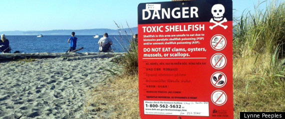
    As a result of testing, people are advised to avoid collecting or eating shellfish from a large area along the Coromandel and Bay of Plenty coastline.

    The area includes the coastline from Tairua (including Tairua Harbour) to Bowentown heads.

    “Sampling confirms high levels of paralytic shellfish poison along this stretch of coast.  We strongly urge people to avoid all shellfish from this area until further notice.  It is unfortunate that this warning has had to be reinstated so soon, however this is a natural occurrence which is difficult to predict,” says Medical Officer of Health, Dr Jim Miller.

    The health warning affects all bi-valve shellfish including mussels, pipi, tuatua, cockles, oysters, scallops, catseyes and kina (sea urchin). Paua, crayfish and crabs can still be taken but as always, the gut should be removed before cooking.

    Consumption of shellfish affected by the paralytic shellfish toxin can cause numbness and tingling around the mouth, face or extremities; difficulty swallowing or breathing; dizziness; double vision; and in severe cases, paralysis and respiratory failure.  These symptoms usually occur within 12 hours of a person consuming affected shellfish.

    Anyone suffering illness after eating shellfish should seek medical attention. Monitoring of toxin levels will continue along the coast and any changes will be communicated accordingly.

    For all health warning updates across the Bay of Plenty and Lakes districts call 0800 221 555. Further information is available at www.toiteorapublichealth.govt.nz/health_warnings

    Shellfish toxin warning lifted


    The paralytic shellfish toxin health warning, which has been in place since December last year, has been lifted for the wider Coromandel and Bay of Plenty coastline.  The area for which the health warning is lifted includes the entire coastline from Tairua (including Tairua Harbour), east along the Bay of Plenty coastline, including Tauranga Harbour, Maketu and Waihi estuaries, to Whakatane Heads.  Also included are Matakana and Motiti islands, and all other inshore islands along this coastline.

    Routine sampling indicates that the levels of shellfish toxin are now within safe limits for the Coromandel and Bay of Plenty coastline.

    “We know the shellfish warning has been an inconvenience, and we would like to thank the public for their endurance and co-operation,” says Dr Phil Shoemack, Medical Officer of Health.

    Although paralytic shellfish toxin is no longer a concern when shellfish gathering, Dr Shoemack wishes to remind people to exercise caution when deciding where to gather shellfish and when preparing shellfish for consumption.

    Non-commercial shellfish collected from the sea and harbours are a high risk food because they tend to accumulate and concentrate in their flesh any contaminants found in the water.  Bivalve shellfish (those with two shells) filter food particles from the seawater and so, for example, can accumulate viruses and bacteria from sewage overflows and farm run-off, toxins from naturally occurring algae, and chemical contaminants such as heavy metals from urban storm water run-off. 

    When shellfish are eaten raw or lightly cooked, bacteria and viruses won’t be killed.  The most effective way to ensure you don’t get sick from eating shellfish is to buy them from the shop or collect them from areas where the seawater is clean and less likely to be contaminated in any way.  It is generally not advisable to collect and eat shellfish from beaches and harbours next to built up urban areas.  Proper handling, storage and cooking can further lower the risk of illness; visit the Food Safety website for more information -www.foodsafety.govt.nz

    For advice on health warnings regarding shellfish collecting, contact your local Health Protection Officer on 0800 221 555 then select option 7 or visit our website www.toiteorapublichealth.govt.nz/health_warnings  

    More rain on the way this weekend


    A broad trough over the Tasman Sea is expected to approach New Zealand late Saturday. An associated front should move onto northern New Zealand during Sunday and Monday, preceded by a strong, moist northeast flow and band of rain.
    Some heavy falls are likely about Northland, northern Auckland, Coromandel Peninsula, Bay of Plenty and Gisborne during this time. However, given the relatively short duration of any heavy falls, there is only low confidence of rainfall amounts reaching warning criteria.
    Meanwhile, another front should move onto southern New Zealand during Sunday and spread over much of the South Island on Monday as a deep low approaches central New Zealand. Brief heavy rain is likely about Fiordland on Sunday, with a low confidence of rainfall accumulations reaching warning levels. Rain should then spread over much of the South Island and lower North Island during Monday and Tuesday. Heavy rainfalls are likely in southern and eastern parts of the South Island, especially about eastern parts of Southland and Otago, where there is moderate confidence of amounts reaching warning criteria. Heavy snowfalls are also possible to low levels in Southland and Otago during Monday and Tuesday and could also reach warning criteria in Canterbury and the Kaikoura Coast on Tuesday.
    Finally, a strong south to southeast flow is expected to develop over southern New Zealand during Monday and persist through Tuesday, with a low risk of winds reaching severe gale in exposed places.
    Details regarding the track and development of the deep low and associated fronts mentioned above are still somewhat uncertain at this stage. However, people in the south and east of the South Island are advised to remain up to date with the latest forecasts as this has the potential to become a significant event.

    More rain, cold winds next week


    A ridge of high pressure is forecast lie over central New Zealand on Friday and should drift slowly eastwards during the weekend.
    A broad trough over the Tasman Sea is expected to approach New Zealand late Saturday. An associated front should move onto northern New Zealand during Sunday and Monday, preceded by a moist northeast flow and band of rain.
    Some heavy falls are likely about Northland, northern Auckland, Coromandel Peninsula, Bay of Plenty and Gisborne during this time. There is low confidence of rainfall amounts reaching warning criteria in these areas, as indicated on the chart.
    Meanwhile, another front should spread onto southern New Zealand during Sunday and spread over much of the South Island on Monday, followed by a cold southerly change. Rain is likely to affect much of the South Island during this time, with snow lowering about the ranges.
    Details regarding the progress and development of the broad trough and associated fronts mentioned above are still uncertain at this stage.

    Highways clean up underway

    The NZ Transport Agency  and their contractors have worked hard to reinstate access to state highways closed around the region due to the severe weather event earlier this week. There are still some remaining cleanup operations underway. The NZTA is advising motorists to continue to take care on state highways around the Coromandel and Bay of Plenty until this work is complete.


    The Karangahake Gorge on State Highway 2 between Waihi and Paeroa is open to single lane access while road crews continue cleaning up.


    · Both lanes on State Highway 2 between Bruce Road and Domain Road, Papamoa are open during the day. From 7.00pm - 6.00am overnight repair works will be undertaken and there will be single south bound lane access only with a detour in place for north bound motorists. The two lane access will be reinstated each morning. Speed restrictions will remain in place until necessary repairs to the road surface are completed, which is expected to take until the end of the week.


    · Both lanes through State Highway 2 Athenree Gorge are now open, although speed restrictions will remain in place until all slip material has been removed from the area. This is likely to be later this week, weather dependent.


    Ms Boyt says the cleanup is likely to continue for most of the week. “We are still asking drivers to take extreme care on the highways while we are clearing slips and reinstating access to state highways closed around the region due to the severe weather event earlier this week. Please drive to the conditions, and allow more time for your journey so that you can reach your destination safely.”


    Ms Boyt says before starting their journey people should check with the NZTA's freephone 0800 4 HIGHWAYS or 0800 44 44 49, or its website www.highwayinfo.govt.nz for up-to-the-minute info on road conditions.

    Continued care urged on highways

    The NZ Transport Agency (NZTA) is advising motorists to continue to take care on state highways around the Coromandel and Bay of Plenty.


    - The Karangahake Gorge on State Highway 2 between Waihi and Paeroa is still closed. River levels through the gorge are receding but significant work is still needed to clear slips and debris; therefore the road will be closed for the rest of the day.
    - Alternative routes are available and motorists are advised to either:
    - drive south on SH2 from Waihi then SH29 via Tauranga over the Kaimais (for Bay of Plenty motorists). However, motorists should also be aware that there is a short detour further down SH2 at Apata and caution is required (see below), or;
    - drive north on SH25 and then SH25A between Kopu and Hikuai (for Coromandel motorists).
    - State Highway 25 between Thames and Coromandel Town is now open. Motorists are being cautioned to take care as debris is still being cleared from this stretch of SH25 and the NZTA is continuing to monitor this section closely.
    - A section of State Highway 25 between Coromandel Town and Whitianga is still closed due to a major slip at between Whangapoua and Te Rerenga.
    - State Highway 29 on the lower Kaimais (Waikato side) - the cleanup is continuing in relation to some isolated small slips and a number of pot holes. Contractors confirm there are no delays to traffic and both lanes are open - but motorists are asked to take care when travelling through the clean up areas.
    - On SH2, the Athenree Gorge remains open to one lane. Work crews are currently working on clearing this slip.
    - Also on SH2 at Apata, a short section of road is closed between Katikati and Tauranga due to a slip and will remain closed for the rest of the day. A short detour is in place along Apata Station Road. Crews are working to clear the slip now.
    - SH2 between Bruce Road and the Domain Road intersection, surface flooding has caused the closure of the north bound lane but the south bound lane is clear. A detour for north bound drivers is in place along Papamoa Beach Road and it will remain in place for the remainder of the day. Motorists are advised to expect delays.
    - SH30 at Rotoma Hill - there are isolated slips. The road is open but drivers still need to take care.
    "The NZTA will continue to closely monitor all roads within the area with heavy rain due to continue to fall until later today. If drivers must travel we urge that they take extreme care on the highways, drive to the conditions, and allow more time for their journeys so that they can reach their destination safely," says the NZTA's Acting State Highway Manager, Karen Boyt.
    Ms Boyt say's before starting their journey people should check with the NZTA's freephone 0800 4 HIGHWAYS or 0800 44 44 49, or its website www.highwayinfo.govt.nz for up-to-the-minute info on road conditions.

    Flooding keeps state highways closed


    A motorist in Katikati was stranded after heavy rain caused
    flooding. Photo: Matty Donaldson. 

    The NZ Transport Agency is advising motorists to continue to take care as heavy rain has caused flooding and slips around the region
    Heavy rain warnings are still in place for the area and flooding and slips will continue to affect a number of roads over the next 24 hours:

    The Karangahake Gorge on State highway 2 between Waihi and Paeroa is still closed. River levels through the gorge are receding but there will be significant clearing of the road before it can open.
    Also on SH2, the Athenree Gorge remains open to one lane. Work crews will begin the slip clean up this morning.
    Motorists are advised to use either SH29 via Tauranga over the Kaimais (for Bay of Plenty motorists) or SH25A between Kopu and Hikuai (for Coromandel motorists) as alternative routes and avoid SH2 until flood waters recede.
    State Highway 25 between Thames and Whitiangia is closed due to major slips at Te Puru and Te Rerenga and a number of other small slips.
    SH26 between Paeroa and Te Aroha is open.
    State Highway 26 at the Criterion Bridge, Paeroa is open.
    State highway 29 on the lower Kaimais (Waikato side) there are isolated small slips and a number of pot 
    holes, contractors are on their way to repair these.
    State highway 2 near Whakamarama is closed due to a major slip blocking the road. Diversions are in place.   
    SH2 between Bruce Road and the Domain Road intersection, surface flooding has caused the closure of one lane. A short detour is in place, and is likely to remain in place for the remainder of the day.
    SH30 Rotomas, there are isolated slips, so while the road is open drivers need to take care.
    "The NZTA will continue to closely monitor all roads within the area with heavy rain due to continue to fall until later today. If drivers must travel we urge that they take extreme care on the highways, drive to the conditions, and allow more time for their journeys so that they can reach their destinations safely." says the NZTA's Acting State Highway Manager, Karen Boyt.
    Ms Boyt say's before starting their journey people should check with the NZTA's freephone 0800 4 HIGHWAYS or 0800 44 44 49, or its website www.highwayinfo.govt.nz for up-to-the-minute info on road conditions.

    Rising river closes Karangahake Gorge


    The NZ Transport Agency is advising motorists that the Karangahake Gorge on State highway 2 between Waihi and Paeroa is closed due to rising river levels through the gorge. Heavy rain warnings for the Coromandel have been issued and are expected to affect the area over the next 24 hours.
    Motorists are advised to use either SH29 via Tauranga or SH25A between Kopu and Hikuai as alternative routes and avoid SH2 through the Karangahake Gorge until flood waters recede.
    The Tairua River at Hikuai on State highway 25 is also being monitored as levels rise however high tide has passed and water levels are not expected to affect the road over the next few hours.
    "The NZTA are closely monitoring all roads within the Coromandel area with heavy rain due to continue to fall in the area until tomorrow morning." says the NZTA's Acting Regional State Highway Manager, Karen Boyt.
    "We urge all drivers to continue to take extreme care in the region, drive to the conditions, and allow more time for their journeys so that they can reach their destinations safely." Mrs Boyt say's before starting their journeys people should check with the NZTA's freephone 0800 4 HIGHWAYS or 0800 44 44 49, or its website www.highwayinfo.govt.nz for up-to-the-minute info on road conditions.

    Today: Heavy rain

    A low is slow-moving northwest of Cape Reinga. An associated front is expected to sweep down over the top of the North Island today. A strong northeast airstream ahead of this front is expected to bring a period  of heavy rain to the northeast of the North Island.


     The heaviest falls are expected over eastern parts of Northland today and overnight tonight, and for the Coromandel Peninsula and Bay of Plenty west of Whakatane, where as much as 160mm may fall in places by Monday night.
    People in these areas are advised to watch out for surface flooding, slips and rapidly rising streams and rivers.
    Keep up to date with the latest on conditions - follow us - www.twitter.com/baysnews 

    Rain on the way for western bay

    A low is slow-moving northwest of Cape Reinga. An associated front is expected to sweep down over the top of the North Island today and tomorrow. A strong northeast airstream ahead of this front is expected to bring a period of heavy rain to the northeast and east of the North Island.
    The heaviest falls are expected about the Coromandel Peninsula and western Bay of Plenty where 120 to 160mm are possible and a warning has been issued for these areas.
    Heavy rain is also expected to affect Northland, Auckland, eastern Bay of Plenty, Gisborne and Hawkes Bay where rainfalls amounts may approach warning criteria.
    People in these areas are advised to watch out for surface flooding, slips, rapidly rising streams and rivers, and to keep up to date with the latest forecasts in case this watch needs to be upgraded to a full warning.

    Another Low develops over northern NZ


    On Monday a low from the sub-tropics should move over the north Tasman Sea and become slow moving. On Tuesday and Wednesday another low should develop over northern New Zealand then move slowly southeast. A strong to gale northeast airstream is expected to gradually spread rain over the northeast of the North Island during this period. There is moderate confidence of warnable amounts of rain for the Coromandel Peninsula and western Bay of Plenty during Monday and Tuesday. There is low confidence that rainfall totals will reach warning levels over Northland and north Auckland on Monday, and over Gisborne and Hawkes Bay during Tuesday and Wednesday.
    A ridge should remain across the South Island throughout the period with generally settled weather, however some rain may reach northeastern areas on Tuesday and Wednesday.

    Heavy rain on the way this week


     low over the Tasman Sea is expected to drift onto the North Island later this week. An associated frontal rainband should move southwards over the upper North Island during Tuesday, preceded by a strong, moist northeast flow. There is a moderate risk of heavy rain accumulating to warning levels in Northland,
    northern Auckland, Coromandel Peninsula, western Bay of Plenty and Rotorua during Tuesday, with a low risk of significant amounts of heavy rain over the remainder of Auckland, northeast Waikato and eastern Bay of Plenty.
    There is also a low risk on Tuesday that the strong northeasterlies could gust severe gale in localised places in Waikato, Waitomo and Taumarunui, and a moderate risk that the moist northeast flow could bring warning amounts of heavy rain to Nelson on Tuesday and Wednesday.
    From Wednesday to Friday the frontal rainband is then expected to drift south over central New Zealand, while the low should move onto the North Island during Thursday. There is a potential for significant amounts of heavy rain in Gisborne and Hawkes Bay during Wednesday and Thursday, especially about the ranges, and in Wairarapa and the Kaikoura Coast on Thursday and Friday. The risk of heavy rain accumulating to warning levels in these areas is considered low.

    Risk of heavy rain over the east and north of Northland


    A low over the Tasman Sea is expected to drift onto the North Island later in the week. An associated front should move slowly southwards over the North Island from Monday to early Wednesday, preceded by moist easterlies. There is a moderate risk of heavy rain accumulating to warning levels over the east and north of Northland during Monday and early Tuesday, then for north Auckland, Coromandel Peninsula and western Bay of Plenty on Tuesday. A lesser risk of heavy rain extends to the eastern Bay of Plenty on Tuesday.
    As the front moves down over central New Zealand later Tuesday and Wednesday, a burst of heavy easterly rain is likely for the northwest of Nelson with moderate confidence of warning accumulations there.
    The low should move onto the North Island on Thursday, bringing heavy showers to northern and central regions. Southerlies and scattered rain for the south and east of the South Island.

    Boat and dive gear seized at Maketu


    Honorary Fishery Officers on patrol at Newdicks Beach, Maketu, inspected a 69 year old Mount Maunganui man, landing at the beach in his dinghy.
    The man was found to be in possession of 163 green lipped mussels. The daily individual limit is 50 green lipped mussels per person in the Western Bay of Plenty area.
    As a result of his alleged offending the man had his dinghy and dive gear seized by the Ministry for Primary Industries. The dive gear included a breathing apparatus set, wet suit, dive tanks and other associated equipment.
    Bay of Plenty, Waikato and Coromandel Compliance Manager Brendon Mikkelsen says "This individual now faces likely prosecution through the courts for possession of excess shellfish which carries a maximum fine of up $20,000 and upon any conviction, likely forfeiture of his vessel and dive gear to the Crown. The possible consequences of breaching the fisheries rules in this case should help form a deterrent to others, as well as the continued support from the local community."
    Mr Mikkelsen says "Our Honorary Fishery Officers carried out patrols over Queens Birthday weekend in the Coromandel and Bay of Plenty area and on the whole found most people complying with fisheries regulations."
    Brendon Mikkelsen says members of the public are urged to phone the Ministry's freephone hotline 0800 4 POACHER (            0800 4 76224      ) in confidence if they see any unlawful activity (including suspected poaching and / or offering seafood for sale on the black-market).
    Mr Mikkelsen says "The assistance of the public by reporting suspicious or illegal activity to Fishery Officers is a key element in protecting the fishery and ensures its sustainability for future generations."


    For the latest breaking news follow us on Twitter

    Major oil spill exercise for Coromandel


    A major oil spill exercise is due to be held on the Coromandel next month, taking into account lessons learned during the Rena disaster.                                                 
    The Waikato Regional Council exercise - involving up to 30 staff and including supporting agencies - will trial the use of booms to check their effectiveness in helping keep oil out of environmentally sensitive Coromandel sites.
    The exercise will begin at Whangamata harbour on 12 June and may also include the Otahu estuary and Opoutere harbour, depending on progress with the booming trials.
    Non-toxic sawdust may be used to simulate oil floating on the water, although a final decision on this is yet to be made.
    Regional on scene commander Adam Munro said the council's annual marine spill exercise was normally held over a day at one location, and was designed to deal with the effects of a spill inside a harbour.
    "This year, following on from the Rena disaster, we're exercising up to three days and up to three locations with a view to helping keep oil from a big spill out of the two harbours and the estuary.
    "This will simulate a situation where oil is threatening multiple locations over an extended period, a scenario similar to that which affected the Bay of Plenty after the Rena grounding."
    During that time, the council and Maritime New Zealand developed a series of site specific response plans when it was predicted that oil from the Rena would impact the Coromandel's east coast.
    The narrow entrances to some Coromandel harbour and estuary areas meant there may be a good chance of using booms to help block them off from spills out to sea. However, these narrow entrances also created a number of challenges, including fast flowing tidal currents and limited access points.
    "Because of potential impacts to these important and vulnerable environments every effort should be made to redirect and recover oil before it enters the upper areas of harbours and estuaries, thereby minimizing environmental damage and recovery cost," said Mr Munro.
    "Should a big spill again threaten our region we want to see if our planning, and Maritime NZ's equipment that we use, is up to the task of protecting these environments using blocking booms to keep out as much oil as possible."
    He said the exercise - which may involve limited restrictions on boats using the trial areas - will take into account the recommendations of a post-Rena Maritime NZ report on the use of booms to protect Whangamata, Otahu and Opoutere.
    Mr Munro noted that in the event of a big spill it may not be possible to protect every threatened site using booms and sites would have to be prioritised accordingly.
    "This exercise will be a good opportunity to work with supporting agencies and to judge whether our current equipment is adequate for a range of scenarios.
    "If we think more or different equipment is needed, we'll make recommendations on this to Maritime NZ," said Mr Munro.


    -fuzeworkmedia 

    Aquaculture grants positive for Bay of Plenty sector


    The awarding of four grants for aquaculture programmes by the Sustainable Farming Fund (SFF) is an extremely positive development for New Zealand's aquaculture sector, says the chairman of the Bay of Plenty Regional Aquaculture Organisation action group, Graeme Coates.
    This is the first time that the aquaculture sector has been able to apply to the SFF for grants, following the merger of two Government organisations into the Ministry of Primary Industries. Mr Coates says the introduction of aquaculture to the SFF is further reinforcement of the Government's commitment to the development of the sector.
    The four aquaculture programmes receiving grants from SFF are the Blue Mussel Over-Settlement Project (Marine Farming Association Inc), Oyster Industry Modernisation Project (Aquaculture New Zealand and New Zealand Oyster Industry Association), Environmental Certification for New Zealand Aquaculture (Aquaculture New Zealand), and the Kaitaia Spat Working Group Project (Marine Farming Association Inc).
    Mr Coates says even though the four projects do not specifically involve Bay of Plenty aquaculture operations, all four are of strong interest to the local Bay of Plenty industry and will have long-term relevance to the local sector.
    Aquaculture has been identified as a key focus area under the Bay of Connections regional economic development strategy. An Aquaculture sector strategy was released in 2009, with the Regional Aquaculture Organisation established in 2010 to oversee and implement the actions of the strategy.
    "The aquaculture sector is in its infancy in the wider Bay of Plenty region, but it is a sector that has the potential to make a significant contribution to the local economy.
    "Research has determined that the Bay of Plenty waters are amongst the most productive in New Zealand, with opportunities existing for large scale ocean and freshwater marine farms to farm a range of different species for local consumption and export.
    "There are a number of key aquaculture projects well underway in the Bay of Plenty. The Environmental Certification programme in particular will be important for our future aquaculture sector, as it will provide the future certification structure that will be a benchmark for any regional operations producing for domestic or international markets," says Mr Coates.
    He says the oyster programme is looking at the recovery of oyster aquaculture operations following the spread of a herpes disease.
    "Fortunately this disease has not presented in the Bay of Plenty, however, it has been identified in Coromandel, which is nearby. So obviously we are very interested in how this research progresses and any learnings that we can introduce ourselves.
    "There will also be learnings for us from the mussel and spat projects, and we will continue to liaise with our colleagues around New Zealand on these programmes."
    The next meeting of the Regional Aquaculture Organisation is on 13 June, 2012.

    RENA owner charged


    Maritime New Zealand has charged the owner of the stricken Rena.

    Greece-based Daina Shipping Co has been charged under the Resource Management Act relating to the "discharge of harmful substances from ships" in the coastal marine area.

    The Rena grounded on the Astrolabe Reef off the coast of Tauranga six months ago today.

    The vessel snapped in half on January 9, and the two sections of the vessel had been resting on the Astrolabe Reef.

    The charge carries a maximum fine of $600,000 and $10,000 for every day the offending continues.

    The charge was laid in the Tauranga District Court and is expected to have its first call on May 25.

    It follows the guilty pleas by the captain and navigation officer of the Rena in February.

    The pair pleaded guilty to 10 out of the 11 charges laid by Maritime New Zealand (MNZ).

    The two men are set to be sentenced in the Tauranga District Court on May 25.


    • Debris has washed ashore at Tairua, in the Coromandel (see container and debris recovery section below). Thames-Coromandel District Council staff have started the clean up of the debris, and MNZ, with support from Waikato Regional Council, is continuing to monitor the shoreline.
    • There have been no reports of oil coming ashore in the Bay of Plenty or Coromandel, however, responders remain on standby and there will be ongoing spot checks of Coromandel and BOP beaches over the Easter holiday weekend.
    • While some oil may come ashore, it is important to note that the amount of oil being released from the wreck is only a tiny percentage of the oil released in the big spill in October.
    • An observation flight over  the wreck this morning confirmed light sheen  extending  2-3km  from teh wreck to the north west.
    • The weather forecast for the Astrolabe today is for SE winds of 25 knots (46km/h) gusting to 37 knots (68km/h) and waves of up to 7m, though this is expected to ease later today. Strong winds and rough seas are forecast to continue through until Sunday.
    • People are advised that more debris and possibly small amounts of oil may land on Bay of Plenty and Coromandel beaches over the long weekend, so please take care if using the beach or water. MNZ remains ready to escalate its response should this occur, and members of the public are urged to contact the response team on 0800 645 774  to report any sightings of oil that may come ashore.
    • If members of the public do get oil on their skin, it should be washed off with soap and water. Baby oil or olive oil is also useful for removing it.
    • There have been no reports of any wildlife being affected, but the National Oiled Wildlife Response Team based at Massey University has been alerted and can respond to any reports as needed. The Department of Conservation has also been alerted.
    Salvage
    • There has been no further significant change to the wreck overnight, though salvors have observed further damage to the rear part of forward section and the breaking up of containers in the holds that are visible from the air.
    • Weather conditions permitting, salvors plan to land a three-man team on the forward section of the vessel this afternoon to conduct a closer visual inspection. However this will be dependent on the prevailing sea and wind conditions, with the safety of the salvors remaining paramount.
    • Boat skippers and vessel masters are reminded to take extreme care, as the debris from the wreck poses a significant risk to shipping. A 2NM exclusion zone remains in place for the Astrolabe reef, and navigational warnings continue to remain in force.
    Container and debris recovery
    • Braemar cleanup teams deployed at first light at points along the Bay of Plenty coast to begin collecting debris and assess how much is coming ashore.
    • All available vessels - around a dozen craft including tugs and barges with excavator arms - are on standby, ready to put to sea as soon a s  conditions allow.
    • In addition, aircraft have carried out further flyovers to pinpoint floating debris, including a debris trail made up mainly of timber which has been drifting inside Mayor Island, in the direction of the Coromandel.
    • A yellow part-container  eralier sighted floating on end in this trail  and thought to have sunk, has been located west of Mayor Island.
    • NZ Operations Manager Neil Lloyd says that as always, Braemar's recovery team will prioritise collecting as much debris as possible at sea to try to stop it impacting on the coast line over the Easter holiday weekend.
    • The public are asked to phone 0800 333 771 if they come across any debris washing ashore as soon as possible.
    • Braemar teams are surveying areas including Papamoa Beach, and further north at Tairua and Pauanui, Onemena, and Whangamata. Reports of debris include plastic beads at Papamoa and packets of noodles in the Tairua area.
    • On Matakana Island, teams using tractors, including an iwi workforce, have begun collecting debris including timber.


    -Lisa Rua - chief editor -  lisa@theboplive.net 

    People trapped in Northland floods

    A large low system is crossing  the top of the north island as you read.


    Several people have needed to be rescued from rising flood waters in Northland this morning.
    A severe weather warning has been issued with MetService predicting another 100 to 150mm of rain on top of the two months' worth that has already fallen in parts of Northland.

    Severe southerly gales, gusting up to 120 kilometres an hour, are also expected today.

    The fire service has been called to around 20 incidents so far today, including two people who were trapped in a car in flood water and a family stuck in a flooded house.

    One person was washed down a hill and had to cling on to a tree to prevent getting swept away.
    Kerikeri High School has been closed for the day and will decide whether to re-open tomorrow morning.

    Northland Civil Defence spokesman Graeme MacDonald says widespread flooding is likely across the region and the situation is serious.

    'We're urging people to take appropriate precautions, especially those living in flood-prone areas. We're also asking people not to travel at all and stay off the roads unless absolutely necessary," he said.

    MacDonald says between midnight Saturday and 9am today, 283.5mm of rain had fallen on the eastern hills above Kaeo - roughly twice the 130mm to 140mm of rain that normally falls on the Northland region for the entire month of March.

    "With many of the region's rivers already seriously affected by the rain that has already fallen, more rain along the lines of that forecast, coupled with a 2.4 metre high tide along the east coast about 6pm today, means the likelihood of more serious flooding is looking increasingly likely."

    The severe weather warning covers Northland, north of Auckland, Coromandel Peninsula and Gisborne.

    Forecasters said a deep sub-tropical low could bring a month's worth of rainfall in just 24 hours.
    Flooding has been reported at Bulls Gorge over both lanes on State Highway 10 south of Kerikeri.

    Police are also advising motorists in the Kaeo area to drive with care due to flooding on some roads.

    State Highway One at Whakapara and several other roads in the Whangarei District have also been flooded.

    Trees or slips are also blocking some roads in the area.

    The stormy conditions are being caused by a deep low pressure system which is lying northeast of Northland, and is expected to track across the country to Hawke's Bay this afternoon.

    Forecasters are warning of the possibility of heavy rain affecting the area from Auckland, south to Taranaki and east to Hawke's Bay.

    The heavy rain will be accompanied by strong southeasterly gales, which could become severe along the west coast of the North Island this afternoon. A severe gale warning has already been issued for Northland.
    The rain is expected to ease tomorrow in the north, but strong winds are forecast to continue.

    Meanwhile a severe weather warning has been issued for Taupo,  this could bring severe gales to the central north island.  Heavy rain is expected in the Bay of Plenty from this afternoon into Tuesday Evening,  with the possibility of flooding in some parts.

    The Wioeka Gorge remains closed, and people are advised not to go near it as more debry is expected to slip with the weather conditions as they are.

    -TVNZ / Lani Hepi

    Deep low makes landfall in lower NI

    UPDATED 8:05am --- Reports of significant damage to some homes, powerlines and trees are starting to filter in from South Taranaki and Wanganui this morning following the passing of the weather bomb's centre earlier this morning.

    The storm - which has the very worst of the winds wrapped tightly around the centre - is now moving into the rest of the lower North Island reports WeatherWatch.co.nz.

    Newstalk ZB and WeatherWatch.co.nz are both receiving reports of roofs lost, trees down and dozens of power cuts - with power problems as far north as Coromandel Peninsula and western Bay of Plenty.

    For Aucklanders the winds have been gusty but not as bad as predicted. This is simply due to the strongest winds being more tightly wrapped around the centre of the low - while that means good news for Aucklanders, it means worse news for central New Zealand which will face a stormy several hours ahead.

    The storm - which was dubbed a "Weather Bomb" by WeatherWatch.co.nz on Thursday - has seen the air pressure fall to very low levels. A weather bomb is jargon based on a technical weather term "bombogenesis" which is when a low rapidly forms and deepens over 24 hPa in 24 hours.

    hPa stands for Hectopascal, the unit for measuring airpressure. It's also known as millibars.

    The blue line indicates the most likely track of the low (the very centre of it).
    The red zone indicates the highest risk for Severe Gales (120km/h to 150km/h)
    The yellow zone indicates the risk zone for Gales (60km/h to 120km/h)
    (WeatherWatch.co.nz)


    WeatherWatch.co.nz Levin reader Andrew Blair, which will be on the edge of the centre, or "eye", of the storm right now, says in the past few minutes the airpressure has started falling like a stone. "978.2 hPa Falling very rapidly -2.4 hPa/hr Strong wind and heavy rain"

    Normal air pressure from most lows that cross New Zealand usually lie in the 990 to 1000 hPa range.

    And it's clear the calm centre is tracking around South Taranaki, Wanganui and Manawatu. A number of reports from our readers are wondering "where the storm even is" - as it quietly passes above them.

    But just a small distance south of the centre and it's another story. "Wind up to 117kmph and trees falling in our backyard in Paraparaumu. Pressure was 977hpa but has risen to 978 in the last hr" WeatherWatch.co.nz reader Jo Clarke told us a couple minutes ago.

    The storm is travelling at an incredible speed. Latest WeatherWatch.co.nz projections show the centre of the storm is likely speeding up and will be travelling at around 100km/h later today. In comparison, most tropical cyclones travel at around 10 to 40km/h. In a 12 hour period from 7am this morning to 7pm tonight it is likely to travel 1200kms to the south east - taking it towards the Southern Ocean.

    Gales have also just reached Auckland City in the past hour. Auckland is expected to be on the edge of the Severe Gale belt today according to WeatherWatch.co.nz - with the worst of the winds moving in between now and mid afternoon in the form of sudden gusts. A severe weather warning is in force for the city since yesterday evening from MetService predicting 120km/h gusts.

    WeatherWatch.co.nz said Friday morning that some parts of the city would record gusts to 120km/h in some exposed parts of the city, while more sheltered areas would see gusts to 80km/h - and this does seem to be the case.

    The weather news authority also predicted the Manukau Heads might see gusts to 150km/h. An unconfirmed report overnight says winds have been gusting to 135km/h on the hilly farmland west of Auckland Airport - a normal wind tunnel for westerlies. It's expected to rise even higher this morning on the Manukau Heads.

    Gusts at Auckland Airport - and in Auckland city - are reaching 70km/h at the moment with winds still building.

    The winds will peak late morning or early afternoon for Auckland.

    But even stronger winds lie further south. Wellington has a gale southerly at 70km/h gusting to 120km/h - with the worst of the weather yet to arrive there.

    Meanwhile the "eye" of the storm has passed near Taranaki and is moving into Manawatu now.

    Late last night WeatherWatch.co.nz received the first reports of wind from Taranaki- and in the past hour we've been told conditions have eased, as the centre of the storm (where winds are light and there is no rain) passed by.

    In latest rain radar images the eye of the storm - or the 'centre' as it's more usually known - can be very clearly seen around Wanganui and is heading east quickly towards Bulls, Palmerston North and then over into Wairarapa/Hawkes Bay.

    Residents will most likely notice winds easing and rains easing in these regions.

    But head weather analyst Philip Duncan says people need to realise the winds will come back, possibly stronger, from a more southerly direction later this morning.

    "So we have a belt of severe gales that stretches for 300kms away from the centre of the low - north and south. This takes those winds down over the upper South Island and as far north as Auckland, although Auckland is right on the edge of it. As the low tracks east of Wairarapa, which it will do mid-morning, it will then blast a very strong southerly flow across the North Island and upper South Island".

    Mr Duncan says for many North Islanders the stormy weather has only just begun - or is yet to.

    "As we said yesterday this storm would arrive quite suddenly - that certainly seems to be the case this morning".

    "The bulk of the energy from this storm lies between Nelson and Marlborough in the South Island and Waikato and Bay of Plenty in the North Island - with Auckland right on the edge".

    WeatherWatch.co.nz says due to the national topography not all main centres - which traditionally are built in more sheltered locations - will be hit, but that damaging gales would still hit most North Island regions today, especially in more exposed places like western, southern and eastern coastlines and hilltops south of Auckland.

    WeatherWatch.co.nz has been providing updates all night to our readers and Facebook followers - we will be continuing all day too, so please keep feeding in your latest storm reports and any photos if you can safely take them.

    "Some New Zealanders may be quite surprised as to how fast this storm moves by today, especially based on the heavy media and weather forecast coverage on Friday. However this is an extreme storm that is fairly small in size and moving very quickly through the lower North Island" says Mr Duncan. "It has the potential to be fell trees, lift roofts, blow vehivles off road and cut power. It's a potent, fast moving, storm" says Mr Duncan.


    - WeatherWatch.co.nz

    Severe Weather Watch

    Valid to: 8:34pm Friday 2 Mar 2012


    SEVERE WEATHER WATCH FOR NORTHLAND,AUCKLAND,WAIKATO,COROMANDEL
    PENINSULA,WAITOMO,BAY OF PLENTY ROTORUA,TAUMARUNUI,TAUPO,TAIHAPE,

    GISBORNE,HAWKES BAY,WAIRARAPA,TARANAKI,WANGANUI,MANAWATU,WELLINGTON,
    MARLBOROUGH,NELSON
    ISSUED BY METSERVICE AT 2034hrs 01-Mar-2012

    RAPIDLY DEEPENING LOW EXPECTED TO CROSS THE NORTH ISLAND OVERNIGHT
    FRIDAY AND DURING SATURDAY WITH DESTRUCTIVE GALES AND HEAVY RAIN
    ABOUT CENTRAL AND NORTHERN NEW ZEALAND.

    MetService forecasters expect a low to deepen rapdily as it crosses
    the Tasman Sea on Friday, and to become intense as it crosses the
    North Island overnight Friday and during Saturday. Gale force winds
    are expected over much of the North Island for a time with the
    passage of the low. There is now an increased risk that gale force
    wind winds will also affect the upper South Island for a time as well.
    Marlborough and Nelson have now been included in the Severe Weather
    Watch. In some places, these gales could be severe and damaging.

    A period of very heavy rain is also expected over much of the North
    Island, in Marlborough and also possibly Nelson.

    People in the North Island, Marlborough and Nelson, particularly
    those planning outdoor activities, are urged to keep up to date with
    the latest forecasts as warnings will be issued closer to the event.

    Although strong westerly winds are expected in Hawkes Bay tonight,
    Thursday, the risk of them reaching severe gale strength is
    diminishing.